Kongsberg Seapath 385

Product Details

Availability:

Rental

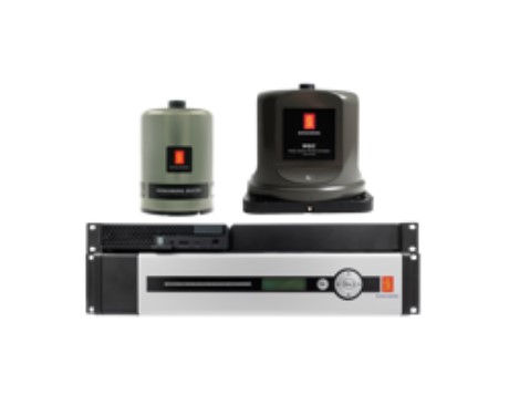
The all-new Seapath 385 is based on the legacy of the Seapath 300-series and incorporates new hardware and advanced navigation algorithms. The Seapath 385 is developed specifically for hydrographic surveying where high-precision heading, position, velocity, roll, pitch, heave and timing are critical measurements. Our solution combines state-of-the-art inertial technology and processing algorithms with multi-frequency GPS, GLONASS, Galileo, Beidou, QZSS and geostationary satellite signals.

Features
  • 0.005° to 0.015° roll & pitch accuracy depending on MRU/MGC
  • 1 cm/1% real-time heave accuracy for heave periods up to 10 seconds
  • 1 cm/1% delayed heave accuracy by use of PFreeHeave® algorithm for heave periods up to 50 seconds
  • Dual 555-channel multi-frequency, multi-constellation receivers
  • All available GPS/GLONASS/Galileo/BeiDou/QZSS satellites used in position solution
  • RTK, Galileo HAS, Fugro G4/G4+ and more corrections supported
  • Includes SBAS corrections (WAAS, EGNOS, MSAS, GAGAN)
  • Includes unique high-precision non-differential position algorithm
  • Spoofing detection and rejection capabilities
  • All data have the same time stamp and to an accuracy of 0.001 s to the actual measurement time
  • Precise Time Protocol (PTP) and NTP available for time critical applications over Ethernet
  • Data available in up to eight different monitoring points
  • Up to 16 configurable output ports on Ethernet or serial line
  • Logging of raw satellite and IMU data possible
  • Remote support capabilities