Kongsberg Seapath 130

Product Details

Availability:

Rental

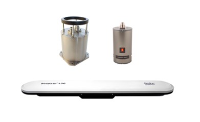
The Seapath 130 series is developed specifically for hydrographic surveying where high-precision heading, position, velocity, roll, pitch, heave and timing are critical measurements. The product combines state-of-theart multi-frequency GNSS receivers, inertial technology and processing algorithms in a compact and portable package.


Features
  • Compact and robust integrated INS/GNSS system
  • 0.007° to 0.015° roll & pitch accuracy dependent on IMU (Inertial Measurement Unit) model
  • No accuracy degradation in roll, pitch and heave measurements during turns
  • Precise heave at long wave periods by use of the PFreeHeave® algorithms
  • 550-channel multi-frequency GPS/GLONASS/Galileo/BeiDou/QZSS receiver
  • Robust against GNSS dropouts due to inertial sensor part of product
  • Multiple differential correction support including SBAS
  • RTK correction on RTCM format supported
  • Seastar®, OmniSTAR® and Marinestarâ„¢ corrections supported
  • All data are provided with a time stamp with an accuracy of 0.001 s to the actual measurement time
  • Outputs on RS-232, RS-422 and Ethernet
  • Up to 100 Hz data output rate
  • Precise Time Protocol (PTP) and NTP available for time critical applications over Ethernet
  • Multi-frequency GNSS ionospheric compensation
  • Logging of raw satellite and IMU data possible
  • Meets IHO exclusive order requirements