QPS QINSy
Availability: Rental
Your objective is to use one software system to collect bathymetry, sonar data and magnetometer data, process this data, produce charts or even produce S-57 Electronic Navigation Charts. QINSy is a suite of hydrographic applications that covers that whole range of activities, from data acquisition to chart production.
Whether it is for dredging, multibeam bathymetry, oceanographic research, site surveys, rig moves, marine construction support, pipeline/cable lay or ROV inspection, QINSy offers efficiency and reliability.
Increasing flexibility by being able to interface any sensor, whether this is a GPS receiver, tide gauge, single or multibeam echosounder, side scan sonar system. QINSy offers a large variety of data exchange formats, such as DXF, S-57, XTF, GeoTIFF, GSF, BAG or ASCII, that allows you to exchange data with many other applications.
From scraping diamonds off the seabed to dumping rock on pipelines, from anchor handling to bathymetric or Side Scan Sonar surveys, its modular design and inherent flexibility makes QINSy perfect for a wide variety of applications;
Hydrographic and Oceanographic Surveys
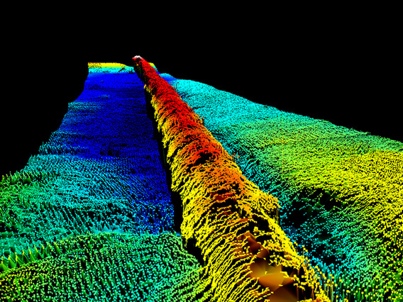
Offshore Pipeline Inspection and Pipe-laying
Dredging, Marine Construction including Offshore Oil and Gas
ROV and AUV Tracking and Data Collection
Barge, Tug and Fleet Management
Chart and ENC Production
QINSy is based on “no limits” and modular design criteria enabling future developments. QINSy forms the cornerstone of QPS’ present strong market position. The key technology behind the success of QINSy is based on precise navigation, data acquisition, presentation, storage and processing large volumes of data all in real-time to produce almost final results on-the-fly. This also includes techniques in real-time 3D visualization of the underwater environment.
As evidence of its extreme flexibility, QINSy is used onboard offshore construction vessels, pipe-lay barges, drilling rigs, seismic research vessels, dredgers and hydrographic survey vessels.
QINSy provides the user a friendly turnkey solution, from survey planning to data collection, data cleaning, volume calculations and chart production. QINSy offers a seamless data flow using a large variety of sensors, all the way to a complete (ENC) chart product.